


Agrometeorological stations network installed across the plain of Arta. All stations have modular design to support different types of sensors. Data are transmitted by GPRS or by UHF to the communications center and they are freely provided in near real time at: https://system.irrigation-management.eu
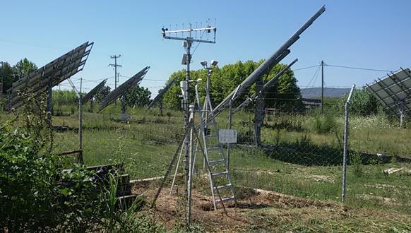
- Agro-Meteorological station at Kostakii campus
-
Infrastructure
(short name)Agrometeorological stations network (plain of Arta) Installation
(short name)UOI Campus Kostakii - S08
(S08)Location Kostakii, Arta Coordinates 39.12, 20.95 Altitude 10 m Description
S08 is an agrometeorological station located at the campus of UOI at Kostakii, Arta.
The station is powered by a PV panel and it is equipped with the following sensors:- Wind speed
- Wind direction
- Rain gauge
- Pyranometer
- Air temperature
- Relative Humidity
- Global - Diffuse radiation - Sunshine duration
- Soil moisture at 3 depths, i.e. 10 cm, 30 cm, 50 cm
- Soil temperature at 3 depths, i.e. 10 cm, 30 cm, 50 cm
Data are transmitted to the communications center gateway, using ADCON A753 addWAVE UHF
Web site address : https://system.irrigation-management.eu/stations/1402/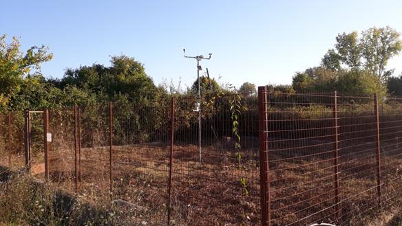
S08 is part of the Agrometeorological stations network installed across the plain of Arta. All stations have modular design to support different types of sensors. Data are transmitted by UHF to the communications center and they are freely provided in near real time at: https://system.irrigation-management.eu
Access to S08 will take place during the regular maintenance visits (2-4 per year). The duration of these visits is usually 1 day and can be extended upon request. Additionally, users can have unlimited access to historical data. Deployment of additional sensors is possible.
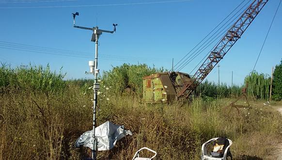
- Agro-Meteorological station at Louros
-
Infrastructure
(short name)Agrometeorological stations network (plain of Arta) Installation
(short name)TOEB Lourou - S02
(S02)Location Louros, Arta Coordinates 39.08, 20.89 Altitude 0 m Description
S02 is an agrometeorological station located at the pumping station of Louros, Arta.
The station is powered by a PV panel and it is equipped with the following sensors:- Wind speed
- Wind direction
- Rain gauge
- Pyranometer
- Air temperature
- Relative Humidity
- Global - Diffuse radiation - Sunshine duration
- Soil moisture at 3 depths, i.e. 10 cm, 30 cm, 50 cm
- Soil temperature at 3 depths, i.e. 10 cm, 30 cm, 50 cm
Data are transmitted to the communications center gateway, using ADCON A753 addWAVE UHF
Web site address : https://system.irrigation-management.eu/stations/1405/
S02 is part of the Agrometeorological stations network installed across the plain of Arta. All stations have modular design to support different types of sensors. Data are transmitted by UHF to the communications center and they are freely provided in near real time at: https://system.irrigation-management.eu
Access to S02 will take place during the regular maintenance visits (2-4 per year). The duration of these visits is usually 1 day and can be extended upon request. Additionally, users can have unlimited access to historical data. Deployment of additional sensors is possible.
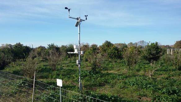
- Agro-Meteorological station at Agios Spiridonas
-
Infrastructure
(short name)Agrometeorological stations network (plain of Arta) Installation
(short name)Agios Spiridonas - S06
(S06)Location Agios Spiridonas, Arta Coordinates 39.15, 20.88 Altitude 10 m Description
S06 is an agrometeorological station located at the Agios Spiridonas, Arta.
The station is powered by a PV panel and it is equipped with the following sensors:- Wind speed
- Wind direction
- Rain gauge
- Pyranometer
- Air temperature
- Relative Humidity
- Global - Diffuse radiation - Sunshine duration
- Soil moisture at 3 depths, i.e. 10 cm, 30 cm, 50 cm
- Soil temperature at 3 depths, i.e. 10 cm, 30 cm, 50 cm
Data are transmitted to the communications center gateway, using ADCON A753 addWAVE UHF
Web site address : https://system.irrigation-management.eu/stations/1403/
S06 is part of the Agrometeorological stations network installed across the plain of Arta. All stations have modular design to support different types of sensors. Data are transmitted by UHF to the communications center and they are freely provided in near real time at: https://system.irrigation-management.eu
Access to S06 will take place during the regular maintenance visits (2-4 per year). The duration of these visits is usually 1 day and can be extended upon request. Additionally, users can have unlimited access to historical data. Deployment of additional sensors is possible.
- Agro-Meteorological station at Kommeno
-
Infrastructure
(short name)Agrometeorological stations network (plain of Arta) Installation
(short name)Kommeno - S09
(S09)Location Kommeno, Arta Coordinates 39.05, 21.01 Altitude 10 m Description
S09 is an agrometeorological station located at the Kommeno, Arta.
The station is powered by a PV panel and it is equipped with the following sensors:- Wind speed
- Wind direction
- Rain gauge
- Pyranometer
- Air temperature
- Relative Humidity
- Global - Diffuse radiation - Sunshine duration
- Soil moisture at 3 depths, i.e. 10 cm, 30 cm, 50 cm
- Soil temperature at 3 depths, i.e. 10 cm, 30 cm, 50 cm
Data are transmitted to the communications center gateway, using ADCON A753 addWAVE UHF
Web site address : https://system.irrigation-management.eu/stations/1406/
S09 is part of the Agrometeorological stations network installed across the plain of Arta. All stations have modular design to support different types of sensors. Data are transmitted by UHF to the communications center and they are freely provided in near real time at: https://system.irrigation-management.eu
Access to S09 will take place during the regular maintenance visits (2-4 per year). The duration of these visits is usually 1 day and can be extended upon request. Additionally, users can have unlimited access to historical data. Deployment of additional sensors is possible.
- Agro-Meteorological station at Kambi
-
Infrastructure
(short name)Agrometeorological stations network (plain of Arta) Installation
(short name)Kambi – S12
(S12)Location Kambi, Arta Coordinates 39.22, 20.91 Altitude 10 m Description
S12 is an agrometeorological station located at the Kambi, Arta.
The station is powered by a PV panel and it is equipped with the following sensors:- Wind speed
- Wind direction
- Rain gauge
- Pyranometer
- Air temperature
- Relative Humidity
- Global - Diffuse radiation - Sunshine duration
- Soil moisture at 3 depths, i.e. 10 cm, 30 cm, 50 cm
- Soil temperature at 3 depths, i.e. 10 cm, 30 cm, 50 cm
Data are transmitted to the communications center gateway, using ADCON A753 addWAVE UHF
Web site address : https://system.irrigation-management.eu/stations/1404/
S12 is part of the Agrometeorological stations network installed across the plain of Arta. All stations have modular design to support different types of sensors. Data are transmitted by UHF to the communications center and they are freely provided in near real time at: https://system.irrigation-management.eu
Access to S12 will take place during the regular maintenance visits (2-4 per year). The duration of these visits is usually 1 day and can be extended upon request. Additionally, users can have unlimited access to historical data. Deployment of additional sensors is possible.
- Agro-Meteorological station at Kompoti
-
Infrastructure
(short name)Agrometeorological stations network (plain of Arta) Installation
(short name)Kompoti – S20
(S20)Location Kompoti, Arta Coordinates 39.10, 21.06 Altitude 15 m Description
S20 is an agrometeorological station located at the Kompoti, Arta.
The station is powered by a PV panel and it is equipped with the following sensors:- Wind speed
- Wind direction
- Rain gauge
- Pyranometer
- Air temperature
- Relative Humidity
- Global - Diffuse radiation - Sunshine duration
- Soil moisture at 3 depths, i.e. 10 cm, 30 cm, 50 cm
- Soil temperature at 3 depths, i.e. 10 cm, 30 cm, 50 cm
Data are transmitted to the communications center gateway, using GPRS
Web site address : https://system.irrigation-management.eu/stations/1407/
S20 is part of the Agrometeorological stations network installed across the plain of Arta. All stations have modular design to support different types of sensors. Data are transmitted by GPRS to the communications center and they are freely provided in near real time at: https://system.irrigation-management.eu
Access to S20 will take place during the regular maintenance visits (2-4 per year). The duration of these visits is usually 1 day and can be extended upon request. Additionally, users can have unlimited access to historical data. Deployment of additional sensors is possible.
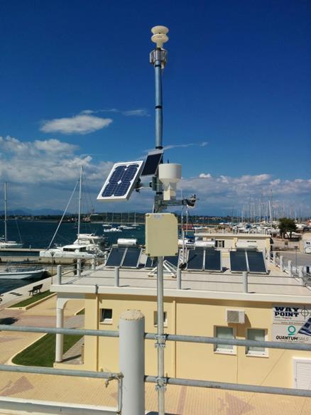
- Meteorological station at Aktion
-
Infrastructure
(short name)Agrometeorological stations network (plain of Arta) Installation
(short name)Aktion
(Aktion)Location Aktion, Preveza Coordinates 38.95, 20.76 Altitude 2 m Description
Aktion is a meteorological station located at the Aktion, Preveza.
The station is powered by a PV panel and it is equipped with the following sensors:- Wind speed
- Wind direction
- Rain gauge
- Pyranometer
- Air temperature
- Relative Humidity
- Barometric pressure
Data are transmitted to the communications center gateway, using GPRS
Web site address : https://system.irrigation-management.eu/stations/1427/
Aktion is part of the Agrometeorological stations network installed across the plain of Arta. All stations have modular design to support different types of sensors. Data are transmitted by GPRS to the communications center and they are freely provided in near real time at: https://system.irrigation-management.eu
Access to Aktion will take place during the regular maintenance visits (2-4 per year). The duration of these visits is usually 1 day and can be extended upon request. Additionally, users can have unlimited access to historical data. Deployment of additional sensors is possible.
- Meteorological station at Lamari
-
Infrastructure
(short name)Agrometeorological stations network (plain of Arta) Installation
(short name)TOEB Lamaris
(TOEB Lamaris)Location TOEB Lamaris, Preveza Coordinates 39.10, 20.73 Altitude 6 m Description
TOEB Lamaris is a meteorological station located at Lamari, Preveza.
The station is powered by a PV panel and it is equipped with the following sensors:- Wind speed
- Wind direction
- Rain gauge
- Pyranometer
- Air temperature
- Relative Humidity
Data are transmitted to the communications center gateway, using GPRS
Web site address : https://system.irrigation-management.eu/stations/1428/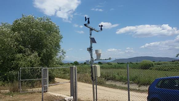
TOEB Lamaris is part of the Agrometeorological stations network installed across the plain of Arta. All stations have modular design to support different types of sensors. Data are transmitted by GPRS to the communications center and they are freely provided in near real time at: https://system.irrigation-management.eu
Access to TOEB Lamaris will take place during the regular maintenance visits (2-4 per year). The duration of these visits is usually 1 day and can be extended upon request. Additionally, users can have unlimited access to historical data. Deployment of additional sensors is possible.