Scientific research in coastal environments is of high priority and great significance for Greece, since they are highly stressed and vulnerable areas prone to degradation from direct human activities. Climate change associated phenomena – temperature and sea level rise, increased frequency of torrential rains and runoff – have adverse effects on the environmental status, at a biogeochemical level; they affect primary productivity and biodiversity, they disturb carbon and nutrients cycles, they intensify beach erosion, coastal inundation and flooding, mixing of fresh and marine waters, as well as depletion of transitional water bodies. Integrated inter-disciplinary research is necessary for the effective management of these areas. NKUA, responsible for the coastal zone component of HIMIOFOTS, enhances capacities towards integrated research and management of coastal environments and inland waters (beach fronts, river deltas, enclosed gulfs, lagoons and lakes), considering present human environmental pressures and climate change phenomena.
The Laboratories of NKUA are fully equipped with infrastructure necessary for the monitoring of the coastal zone.
ACCESSIBLE NODES
- 1) THE DATABASE OF THE COASTAL ZONE
-
The Database of the Coastal Zone includes (A) gridded data and (B) a wide network of available information of the greek coastal environments (marine and land) in several areas of the Greek Seas.A) Gridded data
i) Data obtained by analyzing in-situ observations
It is a reconstructed high resolution gridded interannual dataset of the dissolved oxygen, temperature and salinity by means of variational analysis. The target of the analysis is defined as the smoothest fields that respects the consistency with the observations and a priori knowledge of the background field (climatology) over the domain of interest. The spatial resolution which is used through the analysis for deriving the reconstructed fields is 1/8o x 1/8o and the results are projected on standard depths. The database provides monthly climatological fields as well as annual averaged fields covered the period 1960-2017 for the physical parameters of the coastal zone of the Greek Seas.
ii) Data obtained by model
NEMO community model (Nucleus for European Modelling of the Ocean) in its version 3.6 was selected. A regional configuration has been set up, covering the Mediterranean Sea. The computational grid had a horizontal resolution of 1/36°×1/36° (~2,5 Km) and a vertical grid of 75 geopotential levels applying a step-like representation of bottom topography (z-coordinate with partial step). The model results are organized in 5-days outputs for all oceanic parameters (temperature, salinity, current velocities etc.) which supply the database of the coastal zone for the period 1958-2013. From this node, users could have access to long-term interannual timeseries of the hydrodynamic parameters in order to monitor and evaluate the variability observed in the Greek coastal zone and use the results for academic or other socio-economic applications.B) Network of available coastal information
i) Results- Information from in-situ measurements & Observations
A wide network of information regarding the coastal zone, containing data and analytical results from measurements in different areas of the greek coastal zone. The data has been collected through the National & Kapodistrian University of Athens research activity and contains subaerial coastal zone topography, bathymetry, seabed morphology, sedimentology, nutrients and trace metals, recordings of the presence and distribution of endangered species, Cartilaginous species, marine mammals, overfished species, jellyfish, as well as recordings of human activities (fisheries, aquaculture, industry, tourism, etc.) and their impact on biological resources. Metadata files are in NetCDF format.
ii) Literature platform
Compilation of existing bibliography regarding the coastal zone in the form of a catalogue either at specific sites or at a regional scale. The catalogue is divided into thematic subcategories according to its content and is available in pdf files.
Web site address: http://www.oc.phys.uoa.gr/Himiofots/ - 2) IMAGE ANALYSIS SYSTEM
-
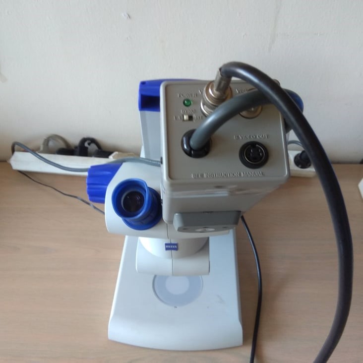
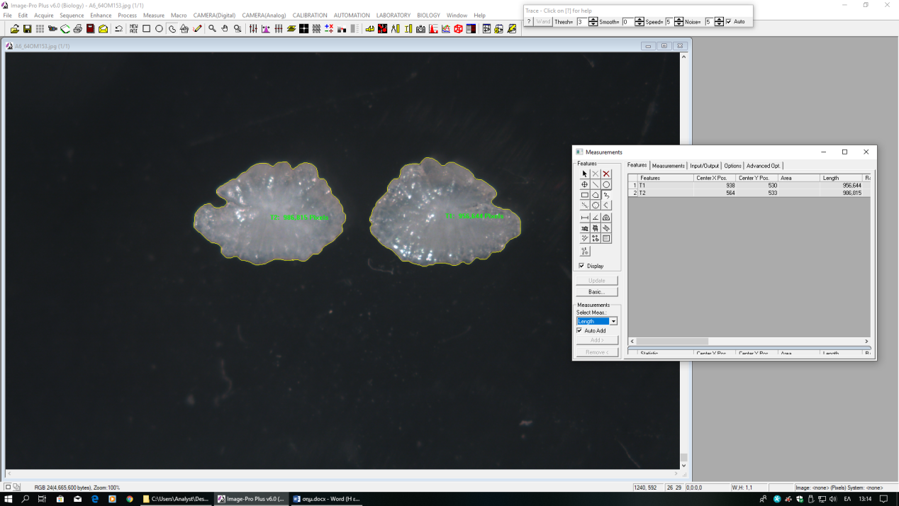
Stereoscope /Image Analysis Pro Plus software/Digital camera Optical microscope and stereoscope with image analysis system/Analog camera
Image Pro Plus is a powerful image analysis software for enriching and editing 2D and 3D images. Facilitates counting, measuring (e.g. length, width, perimeter, area, density) and classifies organisms with high accuracy. By tracing an object of interest, this can be easily classified according to size or other measurement parameters. There is a possibility to trace-monitor a cell or organism as it moves. It is also used for age estimation by counting the growth bands in calcified structures (e.g. scales, otoliths, spine sections) and for observation of histological sections. Using a variety of measurement options, quantified data can be extracted from images. The software also provides a variety of enhancement and edge filters to improve image and tools for macros development.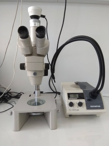
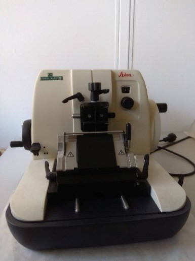
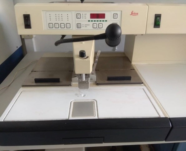
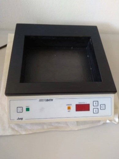
- 3) Μicrotome, water bath and instrument for embedding the tissues in paraffin and cooling
-
The Leica EG1150H is a modern paraffin embedding station with microprocessor control system. It is designed for embedding histological tissue specimens in molten paraffin for use in pathology laboratories and only for the following tasks:
- Melt solid paraffin for sample embedding and maintain the molten paraffin at the required temperature.
- Pour paraffin into embedding molds where the specimens are placed.
- Heat and maintain the temperatures of embedding cassettes with specimens and molds as well as the required forceps.
The Leica HI1210 is a paraffin flotation bath for flattening and drying cut tissue samples used in different fields (e.g. biological and medical research).
- 4) DRONES
-
The Underwater Gladius Mini ROV, 200m is used for monitoring and recording the marine environment and its organisms. It has sensors for measuring different parameters (e.g. water temperature, depth). The main advantage of this underwater drone is to record undersea regions (200 m deep) that are difficult to investigate and provide reliable scientific results. Its main features are: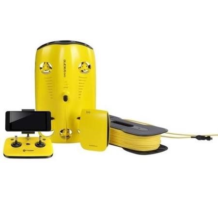
- Maximum depth: 200 m
- Maximum speed: 4 Kn (2 m/ sec)
- ± 45o AdjustableTilt-Lock
- Lighting: 2.400 lumen (LED)
- Camera/Video: Ultra HD camera that delivers 12 M photos and 4K videos
- Virtual Reality
- Live Stream Online
- Battery life: 2 hours
The aerial Drone Mavic 2 Pro is used for monitoring and recording the coastal and marine environments and their organisms (e.g. jellyfish, marine mammals). The aerial drone provides an easier, faster and cheaper method for collecting data. Its main features are:
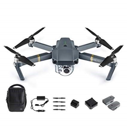
- Camera resolution: 5472x3648 pixels (JPEG/RAW)
- Video resolution: 3840x2160 (4K)/Dlog-M Color Profile/10-bit HDR
- Sensor: 1`` CMOS
- Range: 8 km
- Maximum flight time: 31 min
- Maximum Speed: 72 km/h
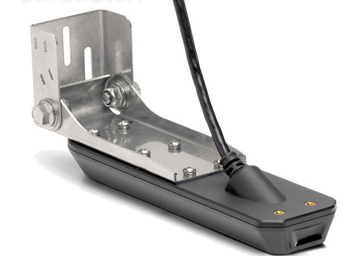
- 5) SINGLE BEAM ECHO-SOUNDER, SIDESCAN SONAR
-
Single beam echosounder coupled with Sidescan Sonar. The system is used for the recording of an area’s bathymetry and sea-bottom habitat classification through backscattering. Maximum depth recording: ~300 m. Triple sounding frequency (455, 800 and 1200 kHZ), for bottom scanning in depths up to 120, 40 and 60 m, respectively and scanning swath of about 300 m, depending on the depth. The system comes with a GNSS receiver (10Hz with EGNOS & GLONASS) and preinstalled nautical charts, whereas the mounting is adaptive to all types of boats.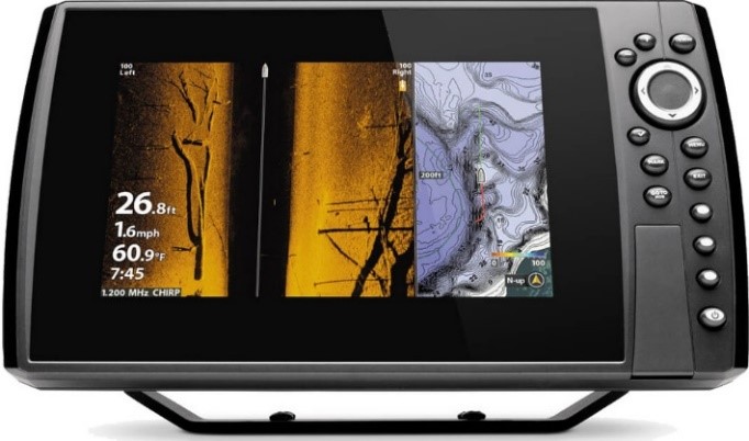
- 6) Portable CTD
-
Portable Device for Temperature, Salinity and Conductivity measurements on-site. Cable length: 25 m, for use in salt and fresh water.
Conductivity measure range:
0-499.9 μS/cm, resolution 0.1 μS/cm, accuracy ±0.5%
0-4999 μS/cm, resolution 1 μS/cm, accuracy ±0.5%
0-49.99 mS/cm, resolution ανά 0.01 μS/cm, accuracy ±0.5%
0-200 mS/cm, resolution 0.1 μS/cm, accuracy ±0.5%
Salinity measure range: 0-80 ppt, resolution 0.1 ppt, accuracy ±2% ή ±0.1 ppt
Temperature measure range: -5 – 95oC, resolution 0.1oC, accuracy ±0.1 oC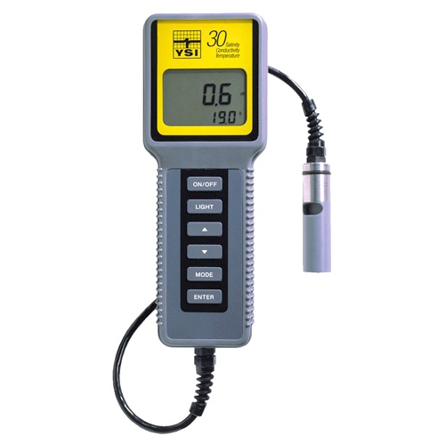
- 7) Portable Tide Logger
-
Data logger for recording water levels and temperatures in the sea, shallow wells, streams and lakes.
Operation range: 0 to 9 m
Pressure and water level range: 0 to 145 kP, resolution: <0.02 kPa and 0.21 cm, accuracy ±0.05%
Temperature range: -20° to 50°C, resolution 0.10°C at 25°C, accuracy ±0.44°C
Logging intervals: from 1 second to 18 hours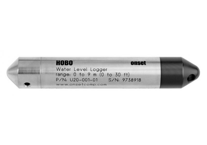
- 8) Portable Wave Logger
-
High-frequency wave-temperature logger
Pressure range: 20/50, resolution 0.001%, accuracy ±0.05%, time constant 0.01s
Temperature range: -5° to 35°C, resolution 0.00005˚C, accuracy ±0.002°C
Logging intervals: 24hr to 1s and 2, 4, 8, or 16Hz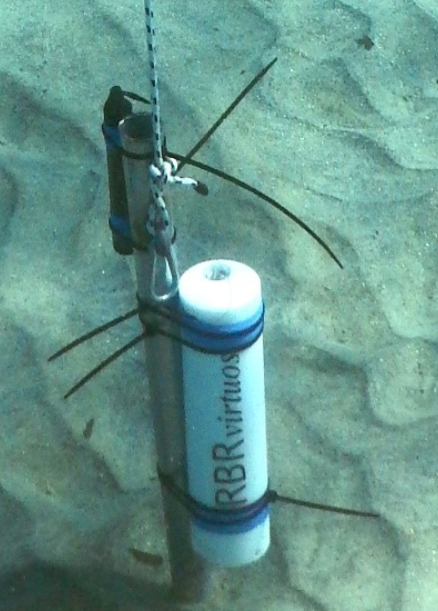
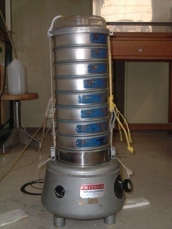
- 9) Dry sieving system (>63μm)
-
Complete system for dry sieving of coarse-grained sediments (≥63μm). Includes two series of sieves from 63μm to 16cm, per ½ φ, drying oven, vibrating device, splitter and distilled water supply system.
- 10) Weather Station
-
Wireless autonomous Weather station and logger with sensors of temperature, wind speed and direction, humidity and rain.
Solar Power Panel : 0.5 Watts
Operating Temperature: -40° to +65°C
Barometric Range: 410 to 820 mm Hg, Resolution 0.1 mm Hg
Temperature Range: 0° to +60°C, Resolution 0.1°C
Heat Index Range: -40° to +74°C, Resolution 1°C
Humidity Range: 1 to 100% RH, Resolution 1%
Rainfall Range: 0 to 6553 mm, Resolution 0.2 mm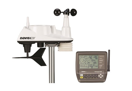
- 11) Water and Sediment Samplers
-
For the collection of water samples from the various water bodies Niskin water samplers (a) are used, whereas for the sampling of surficial sediments the Birge-Eckman grab (b) is used.
a)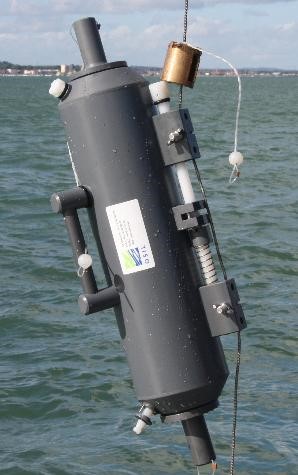 b)
b)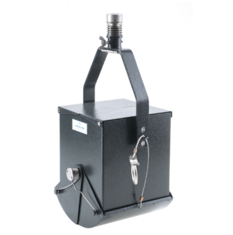
- 12) Double beam UV-VIS spectrophotometer
-
Double beam UV-VIS spectrophotometer with scanning capacity and measuring positions for cuvettes with optical length of 1cm and 5 cm. It is utilized mainly for spectrophotometric methods in aquatic samples (nutrients, chlorophyll) as well as other parameters than can be measured photometrically.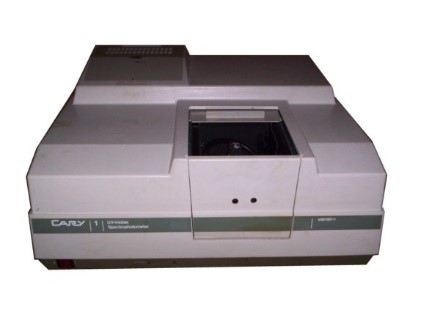
ΝΟΤ ACCESSIBLE NODES
- 1) Inductively Coupled Plasma Mass Spectrometer (ICP-MS THERMO ICAP-Qc)
-
Inductively coupled plasma-mass spectrometry (ICP-MS) is a powerful technique for trace multielement analysis in environmental samples. The benefits of using plasma compared to other ionization methods, such as flame ionization, are that ionization occurs in a chemically inert environment, preventing oxide formation, and ionization is more complete. Also, the temperature profile of the torch is relatively uniform, reducing self absorption effects. However, ICP-MS is prone to interferences caused by sample matrix components. For this reason pretreatment of seawater samples is needed prior the analysis, by using suitable exchange resins or organic solvent extraction techniques.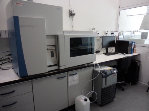
- 2) Laminar flow cabinet CLEAN ROOM (Class 10000)
-
Reliable and accurate measurements of elements and radionuclides at trace and ultra trace concentrations are often needed in a variety of analytical activities related to environmental, nutritional, biological tissues and fluids, and high tech materials. Key components determining the quality of the analytical results include the selection of an appropriate analytical methodology, laboratory environment, reagents, samples and standards and, above all, the experience of the analyst and his approach to the problem. The accuracy with which an element or isotope can be measured at ultra trace levels is limited by systematic errors associated with all the listed parameters, e.g. the very process of sampling and sample preparation which carries the risk of changing the trace element composition of the sample. It is a fact that accurate analysis of a sample is linked to the control of the analytical blank. One of the main sources of contamination of samples is through particulate matter from the laboratory environment. The laboratory determination of elements at trace and ultra trace levels can be jeopardized by the introduction of particulate matter from the laboratory environment. Uncontrolled air usually contains inorganic and organic matter in the form of aerosols of natural and anthropogenic origin. The composition of air particulate matter differs widely depending on the geographical location, extent of industrialization, vehicular traffic, etc. The development of clean rooms/laboratories for controlled environment is the answer to meet the demands of the ultratrace and trace analysis. This includes providing clean room/laboratory facilities for the various steps in sample preparation, storing the samples if needed, purification of chemicals, and finally for carrying out analysis. A cleanroom is a controlled environment that has a low level of pollutants such as dust, airborne microbes, aerosol particles, and chemical vapors. To be exact, a cleanroom has a controlled level of contamination that is specified by the number of particles per cubic meter at a specified particle size. Personnel selected to work in cleanrooms undergo extensive training in contamination control theory. They enter and exit the cleanroom through airlocks, air showers and/or gowning rooms, and they must wear special clothing designed to trap contaminants that are naturally generated by skin and the body.
The Laboratory of Environmental Chemistry is equipped with a Class 10000 clean room where ultratrace and trace analysis of metals including mercury in environmental samples is performed.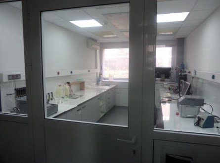
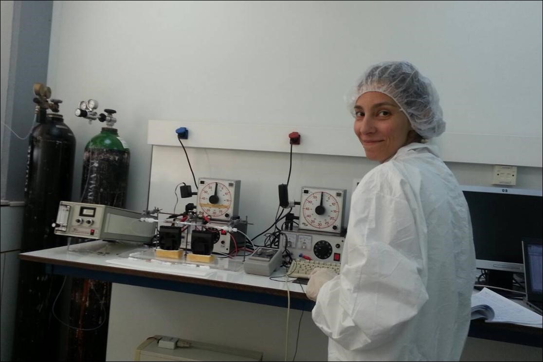
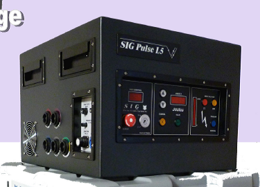
- 3) Sparker
-
The sparker is a seismic trap of the seabed. It is widely used for research in a variety of mapping applications of the upper layers of the bed. The discretion of each system depends mainly on the energy and frequency it emits.
Classically a complete layout of a full spark plug functionality includes:
1) The energy source ranging from 5-30,000 Joule and delivers electricity to the sealed electrodes.
2) The discharge electrodes are water-borne and disposable.
3) The hydrophones capturing the sound waves-reflections of the bottom.
4) The evacuation firing system.
5) The amplification enhancement system of the received reflections.
6) Seismic reflection recording system.
It is digital and the logging system is a computer with a particular software that can include an emergency firing card.